 |
|
NSN provides extensive services that evaluate the type and distribution of benthic resources in near-shore environments. These assessments are typically performed as part of an environmental impact assessment or part of a resource permitting project. These types of projects require an accurate and detailed examination of the presence of benthic resources across a project site, and the potential impacts of the project on the biota and/or substrate across the area of influence. Our services include:
- Sea grass surveys (distribution and species)
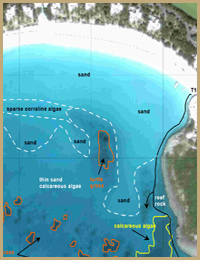
- Delineation of benthic habitats
- Sediment distribution mapping
- Hard-bottom substrate identification
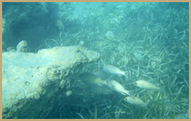
- Fish species classification, abundance and distribution analysis
|
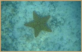
We utilize a combination of techniques to provide accurate assessments of the benthic resources at a project site. Analysis of aerial photographs and literature research provide a first-order examination of the potential resources for a particular site. Our highly trained marine scientists and ecologists will then perform a field investigation using underwater video and photography, as well as sediment sampling and grain size analysis to provide a comprehensive analysis of habitat and species distribution, substrate type, and environmental impact concerns. Certified divers on staff provide the capability of mapping deeper benthic environments. NSN also frequently compliments visual analysis of benthic resources with geophysical mapping. The use of geophysics can provide a rapid method with which to classify substrate and to examine the underlying geologic characteristics of a particular area.
Applications of our benthic resource services include environmental impact assessments, habitat construction and modification, permitting, mitigation, and scientific research.
Examples of Benthic Resource Assessment Projects |