Coastal & Marine Science

  Secondary Links  
 
> Permitting
> Hydrographic Surveys
> Hydrodynamic Modeling
> Benthic Resource Mapping
> Habitat Construction


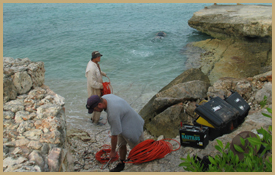
NSN’s team of experienced marine scientists has been involved in a wide variety of marina permitting and coastal engineering projects in the U.S. and abroad.  We incorporate state-of-the-art oceanographic instruments to measure current directions and speeds, water quality, bathymetry, and geologic characteristics of specific coastal environments for site development and habitat construction/conversion.  These data sets are often used in conjunction with detailed computer hydrodynamic modeling to predict the impact of development on coastal hydrodynamics.  Additionally, NSN provides detailed surveys of near-shore environments, including sea-grass surveys, wetland delineations, and coastal sediment mapping.


Content on this page requires a newer version of Adobe Flash Player.

Get Adobe Flash player

 
  Quick Links


Coastal & Marine Science
> Permitting
> Hydrographic Surveys
> Hydrodynamic Modeling
> Benthic Resource Mapping
> Habitat Construction

Hydrogeology
> Water Resource Evaluations
> Well Field Design, Testing, and Permitting

Geotechnical
> Sinkhole Investigations
> Large-Scale Investigations

Geophysics
> MER
> MASW
> CRP
> Sub-Bottom Profiling
> CPT

Case Studies Search:


Copyright © 2008. N.S. Nettles and Associates, Inc.
Web Development by CreativPowers Design