Geophysics - Continuous Resistivity Profiling (CRP)


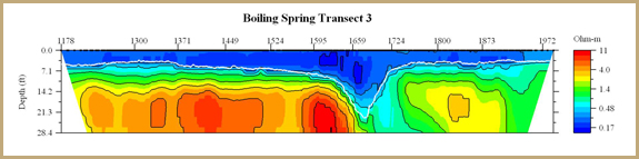
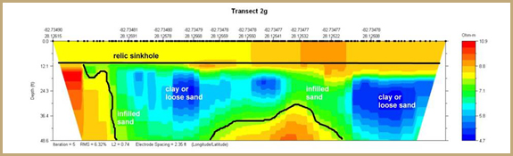
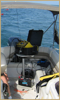
NSN utilizes CRP for rapid large-scale assessment of geology in shallow waters. Recent advances in this resistivity technology make it an accurate and cost-effective method of examining submerged geologic environments.  The system incorporates a set of 11 electrodes which are towed by boat through the water along a grid. The Super Sting unit that controls the CRP system used by NSN was developed by Advanced Geosciences, Inc. (www.agiusa.com).   The CRP arcs an electric current from two current electrodes and records the potential in the trailing nine electrodes.  The underlying geology is mapped in real time, typically moving along the sea floor at a rate of 2 miles per hour.  OET utilizes CRP cables designed to record to depths of 12 feet, 30 feet, 60 feet, and 100 feet (includes water column).  A sonar unit and GPS are connected to the CRP unit to maintain an accurate position file and incorporate bathymetry into the processed data set. The data are compiled to produce a cross-section of resistivity values of geologic strata in the subsurface. This allows for the vertical differentiation of sand, clay, gravel, and rock units. CRP is also effective in identifying buried karst features such as caverns and changes in the porosity of surficial sediments. Some applications in which NSN has utilized CRP technology include:

     
  • Calculating fill sand quantities in inland water bodies
  • Mapping offshore sand deposits
  • Mapping depth to rock in lakes and salt ponds
  • Quantifying dredge depths and in-filled sediments
  • Environmental impact assessments
  • Mapping river beds
  • Mining applications
  • Locating springs
  • Geologic mapping for pipelines
CRP data collection also provides information regarding surface water temperature and bathymetry.  NSN often uses CRP in conjunction with stationary MER transects in order to more closely examine large-scale features identified during a CRP survey.  The continuously recording nature of the test allows for extensive coverage in a single day (as much as 14-18 km).  NSN has performed CRP surveys throughout Florida as well as in the north-central U.S., the Caribbean and Mexico.


  Quick Links


Coastal & Marine Science
> Permitting
> Hydrographic Surveys
> Hydrodynamic Modeling
> Benthic Resource Mapping
> Habitat Construction

Hydrogeology
> Water Resource Evaluations
> Well Field Design, Testing, and Permitting

Geotechnical
> Sinkhole Investigations
> Large-Scale Investigations

Geophysics
> MER
> MASW
> CRP
> Sub-Bottom Profiling
> CPT

Case Studies Search:


Copyright © 2008. N.S. Nettles and Associates, Inc.
Web Development by CreativPowers Design