| Geophysics - Multi-Electrode Electrical Resistivity (MER) |
|
 |
|
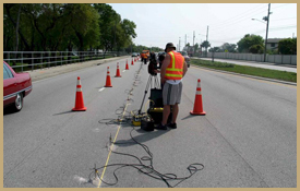
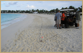
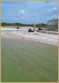
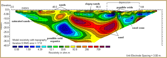
NSN utilizes the most advanced Multi-Electrode Electrical Resistivity (MER) equipment on the market to provide rapid, non-invasive, and cost effective geophysical mapping over any type of terrain. The Super Sting unit that controls the MER system (developed by Advanced Geosciences, Inc., www.agiusa.com) employs 28 to 112 electrodes attached to a cable. On land, the electrodes are coupled to the ground using 24-inch stainless steel spikes. In marine environments, the electrodes can be laid across the ocean floor or towed at the water surface using Continuous Resistivity Profiling (CRP). Several different methods (Gradient-Dipole, Dipole-Dipole, Schlumberger, and Pole-Pole) are used to collect electrical data. These methods are effective in mapping the sands, clays, and limestone units over land as well as in near-shore and offshore environments. Additionally, they are effective in identifying buried karst (sinkhole) features such as vertical solution pipes, ravel zones, caverns, and changes in the porosity of the surficial sediments. Some situations where we have utilized MER mapping include: |
| |
|
|
- Geotechnical investigations
- Subsidence investigations
- Mining exploration
- Sinkhole identification and characterization
- Water supply development (aquifer mapping)
- Dredging projects
- Beach nourishment
- Locating underground tunnels, pipes, drains, etc.
- Mapping near-shore geology
- Delineation of fresh/brackish/saline ground water
Utilizing MER as a first-order assessment of a project site can provide extensive cost savings to the client by helping to focus drilling efforts and quickly identify anomalous subsurface features. A single standard MER transect is the equivalent of 56 separate borings with no data gaps across the profile. |
|
| |
| |
|
|
| |
Advantages of MER:
- Non-invasive, rapid results
- Unaffected by zones such as clays, hardpan, groundwater, unlike GPR
- High resolution shallow geologic detail OR deep penetration into subsurface
- Extremely portable, work in virtually any terrain (terrestrial and aquatic)
- Can record changes in porosity, sediment type
- Cost effective
|
|
| |
|
|
|
| |
NSN has incorporated MER in a wide variety of projects along Florida’s coastline, as well as in the Caribbean and Central America, to map sand deposits and the depth to competent rock units for the purposes of excavation, construction, water supply and beach nourishment. Our electrical resistivity analyses have allowed us to accurately calculate volumes of sand in borrow areas and construction zones, as well as to map ideal subsurface locations for horizontal drilling. Our MER system has been utilized in hundreds of sinkhole investigations across the state of Florida for both private residences and municipal agencies. The combined use of our MER equipment with other geophysical techniques such as MASW as well as more traditional drilling approaches has allowed to confirm the validity of the test, and to present the most rigorous geologic investigations possible to our clients.
Examples of MER Projects |
| |
|
| |
 |
|
|
|