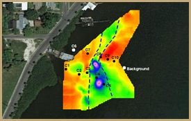
We incorporate the use of geophysics into many of our permitting projects, allowing for a rapid and detailed assessment of the sediment types, thicknesses, depth to rock, and ground water quality of a particular site. Our use of multiple types of geophysical surveys, including electrical resistivity, seismic, and sub-bottom profiling allow us to provide our clients with the most optimal method of investigation for their specific needs. Applications include mapping in-filled sediments in channels, characterizing the geology of a proposed dock or marina construction site, analyzing the groundwater quality and fresh-salt water interface in coastal environments, and determining the presence and/or extent of karst activity.
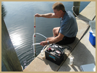
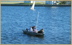
In addition to geophysical surveys, NSN has extensive experience utilizing state-of-the-art water and sediment quality analysis equipment. Some examples of these instruments include continuously recording multi-parameter water quality meters, Acoustic Doppler Current Profilers (ADCP), high resolution water level loggers, data-logging weather stations, vibra-coring, and hand auger borings. The automated capabilities of many of these instruments allow for extensive time-series data sets of water quality, current patterns, tidal flux, and other parameters to be recorded that could not be collected with typical hand-held measurements. The use of these cutting-edge instruments provides our clients with the most accurate and precise data with which to obtain permits. Hydrographic applications include flushing studies, tidal flux and periodicity monitoring, water quality analysis, sediment type and quality analysis, wind and temperature recording, and determination of the depth of the seasonal and mean high water levels (performed for storm water and wastewater disposal mounding analyses).
Our company has also undertaken a multitude of wetland delineations and benthic resource mapping projects. We combine our scientists’ knowledge of wetland systems and/or species distribution in terrestrial and aquatic environments with high resolution GPS recorders to accurately map these areas.
Examples of Permitting Projects |