| Geotechnical Investigations - Sinkholes |
|
 |
|
NSN has performed a multitude of sinkhole investigations throughout the state of Florida and the rest of the country on both small and large scales. We have assisted over 1200 home owners of previously denied insurance claims acquire sinkhole coverage in the past ten years. We have developed a sound hydrogeologic testing protocol for mapping the subsurface geology and locating sinkhole features, incorporating research, traditional field methods, and geophysics into our projects. We have performed sinkhole investigations for condominium complexes in Florida and Tennessee. We have mapped sinkhole features associated with highway road collapse in Florida and Maryland. A growing part of our business is the pre-construction mapping of sinkhole features for commercial and industrial clients. We have successfully utilized MER to map building sites for assisting foundation design in sinkhole environments, and assisted land developers in determining which properties to build on and which should be left as nature preserves. A standard sinkhole investigation performed by NSN would include: |
| |
|
|
- Review of current and historical aerial photographs, topographic maps, soil maps
- Review of any previous borings or other geotechnical work already performed
- Site visit to evaluate conditions and damage (if a structure is already present)
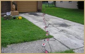
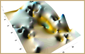
- Geophysical survey of property
- Multi-Electrode Electrical Resistivity (MER) [more info]
- Multi-Channel Analysis of Surface Waves (MASW) [more info]
- Hand auger borings
- Floor slab elevation map
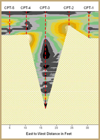
- Cone Penetration Testing (CPT) and/or Standard Penetration Testing (SPT)
- Detailed analysis of data and geologic interpretations
|
|
| |
| |
|
|
| |
 |
|
What is a sinkhole?
Sinkholes are a natural and common feature of areas underlain by limestone or other carbonate sediments. There are several different types of sinkholes. The most familiar type is relatively fast forming cavern collapse sinkhole. A more common type, but less well known to the public is the cover subsidence sinkhole. These sinkholes are very slow moving. They can range from small to quite large in their aerial extent. Whereas the cavern collapse sinkhole leaves no question as to what the operation of earth movement is, the cover subsidence sinkhole is often mistaken for other land subsidence factors such as compression and decomposition of organic sediments, shrink/swell clay, differential settlement or soil slump or creep. NSN has developed testing methodologies designed to recognize the presence of cover subsidence sinkholes. The most common sign of this type of sinkhole is cracks on the interior or exterior of a building or house. |
|
| |
|
|
|
| |
Our extensive testing can identify subtle changes in stratigraphic units (sandy clays, clayey sands, weathered vs. competent limestone) that can help identify sinkhole conditions. Geophysical mapping identifies anomalies in stratigraphic sequences and the CPT or SPT drilling confirms these anomalies and the presence of sinkhole activity (or lack thereof). Hand auger borings across the site provide an alternative method to obtaining physical samples of the surficial soils, and floor slab elevation maps help to identify slopes and depressions in the foundation of a building. NSN has utilized combinations of geophysical and drilling data to accurately calculate the volume of subsurface voids, and provide engineers with quantifiable information for remediation activity (grouting, pilings, etc).
Examples of Sinkhole Projects |
| |
|
|
|
|