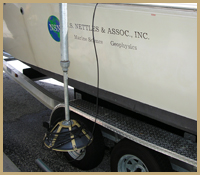
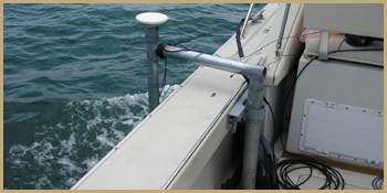
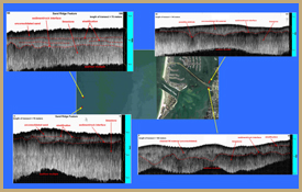
Sub-bottom profiling is a geophysical technique that allows for rapid data collection of shallow geologic features and lithologic information in submerged environments. NSN incorporates a Syquest StrataBox Sub-bottom profiler (www.syquest.com) into many of fresh water and marine mapping projects, typically in conjunction with CRP mapping. The sub-bottom unit collects subsurface data using a reflection sonar technique. The StrataBox operates at a 10 kHz frequency, and is a high-resolution sediment imaging marine geophysical instrument capable of delivering 6 cm of marine sediment resolution with bottom penetration of up to 40 meters. The StrataBox transducer is side-mounted to a vessel in a vertical orientation and maps at a rate of 2 to 4 miles per hour. Subsurface density variations, which correlate to stratigraphic changes (e.g., the sediment-rock interface) are imaged as discrete reflectors. This results in a continuous profile of subsurface sediment interfaces as well as a detailed bathymetry. Post-processing data products include profiles of individual transects with identified reflectors and contour maps showing quantified unit thicknesses. The use of the StrataBox reflection method with additional geophysical tools (such as electrical resistivity) allows for the correlation of different techniques, thereby allowing for greater confidence in the geological interpretation of the subsurface. Some applications in which NSN has utilized sub-bottom profiling include:
- Identifying offshore sand resources
- Quantifying sand volumes in salt pond systems
- Analyzing in-filled sediments in dredged channels
- Quantifying the depth to a rock surface under unconsolidated materials
Sub-bottom profiling is also a beneficial compliment to electrical resistivity surveys due to the lack of interference from buried metal objects or other debris that may cause interference in the electrical tests. The sub-bottom profiling technique is an ideal tool with which to examine major lithologic boundaries. NSN has incorporated sub-bottom profiling into a variety of projects throughout the state of Florida as well as in the Caribbean. The volume of sand and depth to the rock surface calculated in these projects has been found to be extremely accurate, and these quantifications have resulted in successful utilization of submerged sand units. |