| Hydrogeology - Water Resource Evaluations |
|
 |
|
NSN provides comprehensive services to our clients in need of water supply development. The multitude of geophysical tools, drilling techniques, and monitoring plans that NSN is experienced with allow us to evaluate the location, extent, volume, and supply capacity of water resources for our clients at a specific project location. Our approach to developing water resources typically includes: |
| |
|
|
- Research of the project site, analysis of aerial photographs, topography
- Extensive geophysical mapping across areas of potential water supply
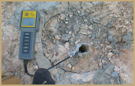
- Multi-Electrode Electrical Resistivity (MER) [more info]
- Multi-Channel Analysis of Surface Waves (MASW) [more info]
- Monitor and test well drilling supervision
- Aquifer performance testing
- Well field design and supervision of construction
- Develop well field operation and maintenance programs
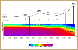
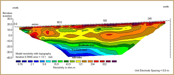
Our combined use of MER and MASW helps to detail the hydrogeology of a project site in multiple ways. The MER surveys clearly define the depth and extent of the groundwater system, the site geology, and the water quality (fresh/brackish/saline). The MASW surveys help to more accurately characterize stratigraphic sequences, soil densities, and the depth/competency of rock units, providing important geologic information for the design of test and production wells. Our extensive experience in designing the correct type of well for any given environment and then providing accurate and quantifiable performance testing of those wells allows our clients to maximize the water supply potential at their project site. NSN has evaluated water resources at multiple sites throughout the state of Florida, in Central America, along the coast of Mexico, and in the Caribbean. These evaluations have resulted in successful water supply development and innovative methods of disposal of effluent waters. |
|
| |
|
| |
 |
|
|
|