 |
|
NSN is experienced in a wide variety of hydrodynamic computer modeling techniques that can be used to understand the impact of development along a coastline or to predict flushing and dispersion patterns for water quality analyses. We utilize several different two-dimensional hydrodynamic models to assess current magnitude and direction at specific project sites, as well as to analyze sediment transport. Our modeling services include:
- Regional, large-scale circulation models
- High resolution, site-specific circulation models
- Wave-Current interaction models
- Sediment transport analysis
- Dispersion models (analysis of contaminant/pollutant dispersion)
- Modeling of river system flow and transport
|
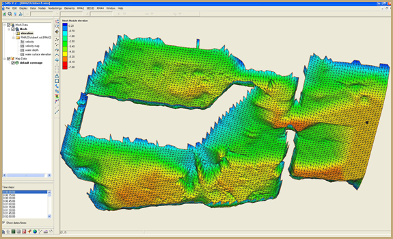
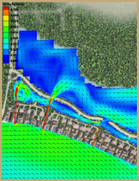
We incorporate both finite-element as well as Cartesian grid domains into our modeling efforts on a project-by-project basis. Our hydrodynamic models include ADCIRC, CMS-M2D, STWAVE, RMA2, and RMA4. Typically, we will utilize a combination of these models to provide a comprehensive analysis of current dynamics, wave propagation, contaminant dispersion and sediment transport. For many projects, regional circulation models are constructed initially, and the hydrodynamic solutions from these models are used as boundary conditions for site-specific investigations.
Hydrodynamic modeling is a tool that can be invaluable in the assessment of potential impacts of new structures or altered coastline morphology on the surrounding environment. NSN has used computer modeling to evaluate the effects of pier/jetty construction, marina development, cutting and dredging, and flushing/contaminant dispersion issues. Models are typically calibrated with field data from Acoustic Doppler Current Profilers (ADCPs), water level loggers, and/or tidal constituents. Detailed bathymetric data is essential for an accurate hydrodynamic simulation. NSN collects our own bathymetric data sets during field investigations to incorporate into our models. These data sets are often complimented by lower resolution offshore bathymetry data obtained through various public databases.
Examples of Hydrodynamic Modeling Projects |